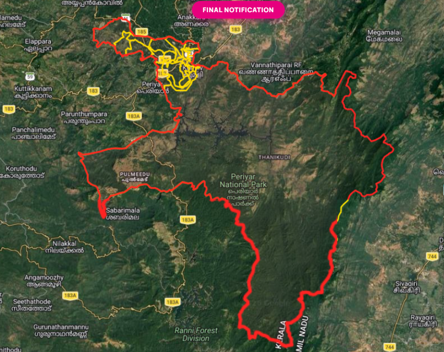
Geography Details
Geographical Profile of Kumily Grama Panchayat
Kumily Grama Panchayat is an important border village panchayat located in Idukki District, in the state of Kerala. Due to its strategic location connecting Kerala and Tamil Nadu, Kumily holds significant commercial and tourism importance.
Location
- Kumily Grama Panchayat is situated in Peermade Taluk of Idukki District.
- It lies along the eastern border of Kerala, adjoining the state of Tamil Nadu.
- The renowned tourist destination Thekkady is located adjacent to Kumily.
- Kumily serves as a major gateway connecting Kerala with the Tamil Nadu regions of Cumbum and Theni.
Boundaries
- The panchayat is located along the Kerala–Tamil Nadu interstate border.
- It functions as one of the principal entry points between the two states, facilitating trade, transportation, and tourism.
Elevation
- Kumily is situated at an elevation ranging from approximately 880 to 1,000 meters above sea level.
- The average elevation of the region is around 900 meters.
Topography
- The area forms part of the Western Ghats, a globally recognized biodiversity hotspot.
- The terrain is characterized by hills, slopes, valleys, and mountainous landscapes.
Climate
- Kumily experiences a moderate and pleasant climate throughout the year.
- Summer temperatures generally range between 15°C and 30°C.
- The region receives substantial rainfall from both the Southwest Monsoon and the Northeast Monsoon.
- Cool weather and relatively high rainfall contribute to its favorable living conditions and agricultural productivity.
Water Resources
- Local water resources primarily depend on rainfall.
- The area is associated with the Periyar River river system.
- The nearby Periyar Lake is an ecologically and tourism-important water body.
- Numerous small streams and water storage structures support agriculture and domestic needs.
Soil Type
- The region is predominantly covered by red soil and forest soil.
- These fertile soils are highly suitable for spice cultivation and plantation crops.
Forest Resources and Biodiversity
- Kumily is located close to the Periyar Tiger Reserve, one of India's most important protected forest ecosystems.
- The area possesses rich biodiversity and extensive forest resources.
- Tree species such as teak, rosewood, and eucalyptus are commonly found.
- A wide variety of wildlife species inhabit the surrounding forests.
Agriculture
Agriculture is a major economic activity in Kumily. The principal crops include:
- Cardamom
- Black Pepper
- Clove
- Nutmeg
- Coffee
- Tea
Kumily is widely recognized as an important spice-producing region of Kerala and plays a significant role in the state's plantation economy.
Transportation and Connectivity
- Kumily serves as a major transportation corridor between Kerala and Tamil Nadu.
- The principal road links to Cumbum and Theni pass through the area.
- It is a key center for interstate trade, tourism, and passenger movement.
Area
- The official geographical area of Kumily Grama Panchayat may vary based on administrative records and revisions.
- The most recent and accurate figures can be obtained from Panchayat records and official government documents.
Summary
Nestled within the Western Ghats, Kumily Grama Panchayat is a prominent border panchayat of Kerala known for its rich forests, biodiversity, spice plantations, pleasant climate, and tourism significance. Its proximity to Periyar Tiger Reserve and Thekkady, together with its strategic location on the Kerala–Tamil Nadu border, makes it one of the most important gateway regions in the state.